
Measure Ground Control
3.7star
44 reviews
5K+
Downloads

Everyone
info


About this app
Measure Ground Control is an “all in one” drone deployment and data management software solution for UAV pilots, small businesses and large enterprises. Create a mission, plan a flight, check airspace, and process your image data in a variety of formats, such as high-quality orthomosaics, 3D maps and 3D mesh, thermal imagery, digital surface models (DSM), and many more. Manage your pilots and drone fleet, create and reuse flight plans, store and maintain fly sites, build flight schedules, run safety checklists and log flight data, as well as create customized data reports.
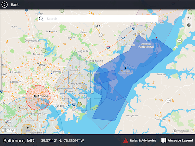
With the ability to navigate seamlessly between the web and mobile applications, Measure Ground Control features LAANC airspace authorization with built-in Airmap technology, so you can fly any airspace safely and FAA compliant. Process and create data products with our advanced photogrammetry and image processing featuring an integrated Pix4D toolkit, or inspect and annotate image data using our custom Scopito integration, all within the convenience of a single software application.
Measure Ground Control offers multiple flight modes including Panorama, Spotlight, POI, Profile, Trace, and Tripod. Additional features can be activated for Enterprise users. Built for universal DJI compatibility.
Device Compatibility
Not all Android compatible devices listed.
Samsung (S20, S10, S9+, S9, S8+, S8, S7, S7 Edge, S6, S6 Edge, Note 20, Note 10, Note 9, Note 8) Huawei (P20 Pro, P20, P10 Plus, P10, Mate 10 Pro, Mate 10, Mate 9 Pro, Mate 9, Mate 8, Honor 10, Honor 9) Vivo (X20, X9) Oppo (Find X, R15, R11) Xiaomi (Mi Mix 2S, Mi Mix 2, Mi 8, Mi 6, Redmi Note 5) Google Pixel 2XL, OnePlus (6, OnePlus 5T)
Highlights
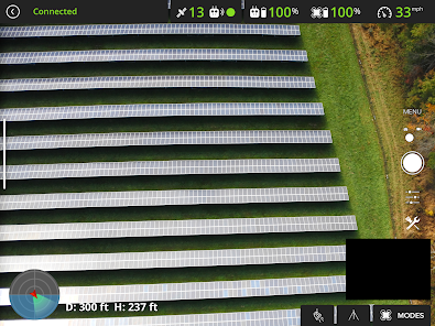
Manual flight mode with live streaming
Grid flight mode with terrain follow
Custom waypoint flight plans
Mission creation and management
Drone fleet & pilot management
Image data processing & custom reports
Custom flight safety checklists
LAANC digital authorization request
Flight logs & realtime flight info
DJI Compatibility
Mavic (all) • Mavic 2 (all) including Smart Controller • Mavic Air 1 • Phantom 3 (all) • Phantom 4 (all) • Exception being the P4P RTK- limited functionality • Inspire 1, 1 Pro and Inspire 2 • Matrice 100/200/210 (all versions) • Matrice 600 & 600 Pro • Mavic Mini • Spark
Plan a Mission
Schedule and manage mission calendar
Assign pilots and equipment and send notifications
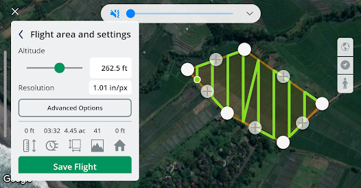
Create a flight plan with a KML file, grid or waypoint plan
Sync flight plans to the mobile flight app
Check airspace and weather
Fly & Collect Data
Request LAANC authorization
Retrieve and apply DJI Geo Unlock
Fly with GPS-aided manual control, automated grid and waypoint patterns
Use active track modes including spotlight, POI, trace, orbit and profile
Automatically upload flight logs and screen captures
Process & Analyze*
Process imagery into high-quality data products powered by Pix4D
Increase image processing accuracy with RTK drone data, or use GCPs info
Create orthomosaics, digital surface models, and contour maps
Measure linear distance and area or add a 2D image layer to your map
Analyze data with our integrated Scopito annotation tool
Report and Store Data*
Store unlimited flight logs, imagery, video, and uploaded files
Track activity and compliance with built-in reports
Export and share data products (orthos, DSM, contours) as GeoTIFF or GeoJSON files
Add inspection results and review mission and portfolio-level summaries
Upload completed data products to each mission
Manage Operations*
Access automatically uploaded flight logs, including flight playback and screen captures
Check automatically flagged incidents for activity outside of safety best practices
Add users, setup user profiles, control user permissions with pre-defined roles
Manage equipment with automatic usage tracking
Track program activity with dashboards and exportable PDF and CSV reports
*Features only accessible via the Measure Ground Control web application.
With the ability to navigate seamlessly between the web and mobile applications, Measure Ground Control features LAANC airspace authorization with built-in Airmap technology, so you can fly any airspace safely and FAA compliant. Process and create data products with our advanced photogrammetry and image processing featuring an integrated Pix4D toolkit, or inspect and annotate image data using our custom Scopito integration, all within the convenience of a single software application.
Measure Ground Control offers multiple flight modes including Panorama, Spotlight, POI, Profile, Trace, and Tripod. Additional features can be activated for Enterprise users. Built for universal DJI compatibility.
Device Compatibility
Not all Android compatible devices listed.
Samsung (S20, S10, S9+, S9, S8+, S8, S7, S7 Edge, S6, S6 Edge, Note 20, Note 10, Note 9, Note 8) Huawei (P20 Pro, P20, P10 Plus, P10, Mate 10 Pro, Mate 10, Mate 9 Pro, Mate 9, Mate 8, Honor 10, Honor 9) Vivo (X20, X9) Oppo (Find X, R15, R11) Xiaomi (Mi Mix 2S, Mi Mix 2, Mi 8, Mi 6, Redmi Note 5) Google Pixel 2XL, OnePlus (6, OnePlus 5T)
Highlights
Manual flight mode with live streaming
Grid flight mode with terrain follow
Custom waypoint flight plans
Mission creation and management
Drone fleet & pilot management
Image data processing & custom reports
Custom flight safety checklists
LAANC digital authorization request
Flight logs & realtime flight info
DJI Compatibility
Mavic (all) • Mavic 2 (all) including Smart Controller • Mavic Air 1 • Phantom 3 (all) • Phantom 4 (all) • Exception being the P4P RTK- limited functionality • Inspire 1, 1 Pro and Inspire 2 • Matrice 100/200/210 (all versions) • Matrice 600 & 600 Pro • Mavic Mini • Spark
Plan a Mission
Schedule and manage mission calendar
Assign pilots and equipment and send notifications
Create a flight plan with a KML file, grid or waypoint plan
Sync flight plans to the mobile flight app
Check airspace and weather
Fly & Collect Data
Request LAANC authorization
Retrieve and apply DJI Geo Unlock
Fly with GPS-aided manual control, automated grid and waypoint patterns
Use active track modes including spotlight, POI, trace, orbit and profile
Automatically upload flight logs and screen captures
Process & Analyze*
Process imagery into high-quality data products powered by Pix4D
Increase image processing accuracy with RTK drone data, or use GCPs info
Create orthomosaics, digital surface models, and contour maps
Measure linear distance and area or add a 2D image layer to your map
Analyze data with our integrated Scopito annotation tool
Report and Store Data*
Store unlimited flight logs, imagery, video, and uploaded files
Track activity and compliance with built-in reports
Export and share data products (orthos, DSM, contours) as GeoTIFF or GeoJSON files
Add inspection results and review mission and portfolio-level summaries
Upload completed data products to each mission
Manage Operations*
Access automatically uploaded flight logs, including flight playback and screen captures
Check automatically flagged incidents for activity outside of safety best practices
Add users, setup user profiles, control user permissions with pre-defined roles
Manage equipment with automatic usage tracking
Track program activity with dashboards and exportable PDF and CSV reports
*Features only accessible via the Measure Ground Control web application.
Updated on
Safety starts with understanding how developers collect and share your data. Data privacy and security practices may vary based on your use, region, and age. The developer provided this information and may update it over time.

No data shared with third parties
Learn more about how developers declare sharing

This app may collect these data types
App activity and App info and performance

Data is encrypted in transit

Data can’t be deleted
Ratings and reviews
3.6
41 reviews

william hartig
- Flag inappropriate
- Show review history
May 16, 2021
Okay i just worked out why the images were not on the SD card. The drone settings were to save images onto internal memory-the other awesome thing was, i could connect to drone internal memory via the app to extract images onto my phone. . This is an an amazing app. No nilly nellying around, once flight checks are done it does the job for you. It is simple and straight forward, got me the results I needed for what I wanted to do. 11/10 to the developers!!
9 people found this review helpful

MAP ENGINEERING Ltd.
- Flag inappropriate
February 3, 2024
First attempt to fly a grid mission. The drone is DJI Mavic 2 Pro on Bison GT phone with Android 10. The drone took two lines of the grid mission and after that it stopped in the sky. Had to take it down manually. Didn't have time for more attempts, so I used pix4d app and did the task. Also, I couldn't find a way to import KML file. I see the "USE KML" option, choose file to be used, but it doesn't appear on the map. For sure I'll give the app second try and hope to get answers of the questons

Kal Friesen
- Flag inappropriate
- Show review history
July 8, 2023
Update, in airspace map, it says " Unable to load map" to load the map requires an active internet connection on the device. Make sure your devices wifi or LTE connection is working. My internet connection is working. Side question, does this app work with the dji mini 2, if so which camera sensor do I choose when creating a flight plan?
Measure Digital Products
July 7, 2023
Hi Kal, maps not loading suggests that there is an issue with your internet connectivity. Please ensure that you have a stable internet connection and that there are no internet restrictions placed on the MGC app by any security or child-monitoring app. Please contact us at support.groundcontrol@ageagle.com if the issue persists.
What's new
- Added Field Check Overlap Analysis for MicaSense cameras.
- Added support for additional cameras for flight planning (MicaSense Altum-PT, MicaSense RedEdge-P, Zenmuse P1).
- Improved recommended speeds for cameras during flight planning.
- Added support for additional cameras for flight planning (MicaSense Altum-PT, MicaSense RedEdge-P, Zenmuse P1).
- Improved recommended speeds for cameras during flight planning.