

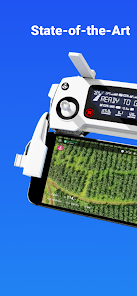
DroneDeploy - Mapping for DJI

3.5star
4.3K reviews
500K+
Downloads

Everyone
info


About this app
DroneDeploy is the leading cloud software platform for commercial drones, and is making the power of aerial data accessible and productive for everyone. The free DroneDeploy app provides easy automated flight and data capture, and enables you to explore and share high-quality interactive maps, orthomosaics and 3D models directly from your mobile device.
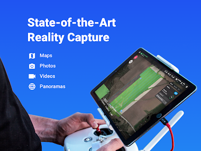
Fly your DJI drone autonomously with just two taps on your Android device. Quickly process your imagery with DroneDeploy to generate high-resolution maps and 3D models, analyze, annotate and share your maps with others directly from within the app. Extend your capabilities and take your analysis to the next level with over 80 best-in-class apps available for install within DroneDeploy’s App Market.
DroneDeploy is the ultimate app for a wide range of aerial imaging and mapping applications in construction, solar, agriculture, surveying, mining, insurance and inspection and more. DroneDeploy has empowered users to map and analyze over 30 million acres in more than 160 countries.
Compatible with DJI’s latest drones:
- Mavic 2 Pro / Zoom / Enterprise
- Phantom 4 Pro
- Matrice 200 / 210 /210 RTK V1/V2
Not Compatible with the Following Hardware:
- DJI Mavic Mini series
Android 10+ Recommended
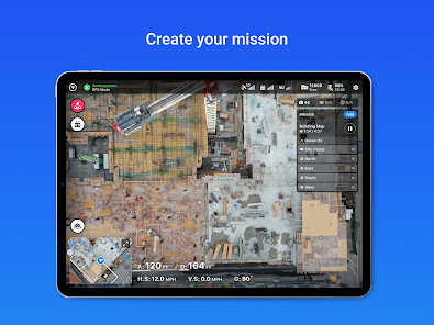
Automated Mapping for Beginners and Professionals:
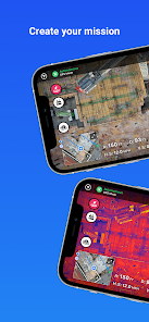
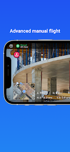
- Easily make flight plans on any device
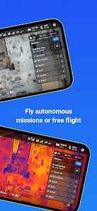
- Automate takeoff, flight, image capture and landing
- Live stream First Person View (FPV)
- Disable auto-flight and resume control with a single tap
- Easily continue non-interrupted flights to map large areas
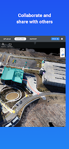
In-field data analysis on any device:
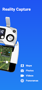
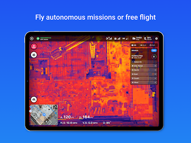
- Explore Orthomosaic, NDVI, Digital Elevation interactive maps and 3D models.
- Measure elevation, distance, & area
- Measure volume (paid customers)
- Collaborate with a team through shared maps and comments
- Get help when you need it with in-app support (paid customers)
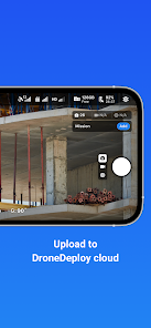
Image processing and analysis available on dronedeploy.com:
- Upload imagery from your drone’s SD card to www.dronedeploy.com to process high resolution 3D maps
- Process ground control points to create high accuracy maps and models
- Export data in the format you need
Please join us in improving and discussing the app at http://forum.dronedeploy.com
Fly your DJI drone autonomously with just two taps on your Android device. Quickly process your imagery with DroneDeploy to generate high-resolution maps and 3D models, analyze, annotate and share your maps with others directly from within the app. Extend your capabilities and take your analysis to the next level with over 80 best-in-class apps available for install within DroneDeploy’s App Market.
DroneDeploy is the ultimate app for a wide range of aerial imaging and mapping applications in construction, solar, agriculture, surveying, mining, insurance and inspection and more. DroneDeploy has empowered users to map and analyze over 30 million acres in more than 160 countries.
Compatible with DJI’s latest drones:
- Mavic 2 Pro / Zoom / Enterprise
- Phantom 4 Pro
- Matrice 200 / 210 /210 RTK V1/V2
Not Compatible with the Following Hardware:
- DJI Mavic Mini series
Android 10+ Recommended
Automated Mapping for Beginners and Professionals:
- Easily make flight plans on any device
- Automate takeoff, flight, image capture and landing
- Live stream First Person View (FPV)
- Disable auto-flight and resume control with a single tap
- Easily continue non-interrupted flights to map large areas
In-field data analysis on any device:
- Explore Orthomosaic, NDVI, Digital Elevation interactive maps and 3D models.
- Measure elevation, distance, & area
- Measure volume (paid customers)
- Collaborate with a team through shared maps and comments
- Get help when you need it with in-app support (paid customers)
Image processing and analysis available on dronedeploy.com:
- Upload imagery from your drone’s SD card to www.dronedeploy.com to process high resolution 3D maps
- Process ground control points to create high accuracy maps and models
- Export data in the format you need
Please join us in improving and discussing the app at http://forum.dronedeploy.com
Updated on
Safety starts with understanding how developers collect and share your data. Data privacy and security practices may vary based on your use, region, and age. The developer provided this information and may update it over time.

No data shared with third parties
Learn more about how developers declare sharing

This app may collect these data types
Location, Personal info and 3 others

Data is encrypted in transit

You can request that data be deleted
Ratings and reviews
3.2
3.96K reviews

David B
- Flag inappropriate
November 17, 2023
It's been awful. The more I use this app, the worse it seems to work. DD works poorly with dji(my drone). I have just about given up flying in restricted airspace. The authorizations, softwares which are barely compatible. It took a half dozen attempts this morning to get the bird in the air. Very stressful. Going to give pix4d a try. It can't be much worse. Many of my drone friends have switched from. DD to pix4d. They seem happy. I am Miserable!!!
13 people found this review helpful

A Google user
- Flag inappropriate
- Show review history
November 28, 2019
Keeps crashing out on Samsung Galaxy Note 10+ and Galaxy Tab S4. Unable to complete drone jobs because of it. Sometimes resumes mission, othertimes wants to reset it. Not sure if it still captures images when the drone keeps flying while the app is crashed. UPDATE 11/28/2019: Although I had issues with the app. Tech support and customer service have been great to work with. Resolved my issues, responded in a timely manner, and really stepped up to help out. Thank you
29 people found this review helpful
DroneDeploy
November 28, 2019
Hi Chris, Android 10 is supported in version 4.0, available now. Please note that Android 10 support was blocked by DJI who we have worked with to resolve. Appreciate your patience and happy flying!

Scott Schlief
- Flag inappropriate
- Show review history
January 27, 2023
I can't get past the checklist. Keeps trying to get me to change settings i don't have the ability to change. Have to unplug and replug the phone each time i switch apps to try and change settings. I'll try to debug a few more times, but then I'm going to give up and delete the app. Uodate: Got past the checklist... Did the flight... Still not sure how to access the data. I think i have to upload everything? Instructions are unclear.
31 people found this review helpful
What's new
Includes our latest fixes for speed and reliability. Thanks for flying with DroneDeploy!


